TnT Adventure Trails is a blog that delves into the adventures of exploring the beauty of the vast nature trails of the twin islands of Trinidad and Tobago. These write-ups give the reader descriptions and insights into the experiences of others who have embarked on these fun-filled outdoor adventures.

07 August, 2016

Gasparee Caves

'Welcome to Gaspar Grande'
The closest island to Chaguaramas Bay, up the northwestern archipelago, Gaspar Grande houses underground caves which were once used by pirates and smugglers for hidden treasures. Gasparee Caves, situated at Point Baleine on the northwestern end of Gaspar Grande Island, is one of Trinidad’s most popular tourist attractions. 
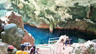
Staircase leading inside
Leading to the cave there is a concrete footpath, and the refurbished gunnery at the top of the hill. The journey begins at Point Baleine, ten minutes from the cave lodge, with the assistance of a tour guide to explore this natural wonder as the trail descends to the shimmering waters of the underground pool, in which is reflected the surrounding stalactites and stalagmites. 

Pool inside cave
Its unique translucent blue pond, which has an average depth of 10-20 feet is what makes this cave so appealing. Seawater emerges through an underground source into the cave to create this natural pool. 
Overview of cave


Cave formations
Due to the wave action, acidic rainfall and percolating ground-water, the limestone has been dissolved, forming sculptured caverns, caves and sinkholes which make up Gasparee Caves. Gasparee Caves are approximately 90 feet deep, with the underground limestone system consisting of three main areas: The Entrance, The Twilight, and the Dark Zone. In each, fascinating geological formations are enhanced by natural light reflections. The Twilight Zone also has a saline pool, three feet deep at its shallowest.

War cannon
Some fascinating creatures found at this site are bats in the cave, the yellow-headed parrot, rufus-necked wood rail and pelicans.

Additionally, a trek across Gaspar Grande will lead to a World War II cannon originally mounted for the defence of the bay. Finally, before returning to Chaguaramas, a boat trip can be taken around the tip of the mainland to Scotland Bay for a soothing sea bath.

The Tourist Development Company of Trinidad and Tobago restored the cave to accommodate visitors with an inside staircase and supplied electricity. The cave is managed by the Chaguaramas Development Authority (CDA) who conducts daily tours to the Island.


Geography Facts:
  • Island’s geological features consist of limestone which is sedimentary rock formed under the sea and composed of coral, oolites, seashells and other marine creatures.
  • The cave originated when water deposits of carbon dioxide dissolved the limestone into crystals of calcium carbonate, a chemical formula known as CaCO3 which is a compound of calcium, carbon and oxygen. 
  • Over time, the accumulations of crystals create stalagmites, which extend up, from the cave floor, and stalactites extend down from the roof. Those that stem all the way from the ceiling to the ground are called pillars. Some of the crystals transform into fascinating shapes, resembling a dinosaur head, a chandelier, two lovers hugging and even flowers.


Historical Facts:
  • In 1783, Governor Don Jose Maria Chacon granted the island to Gaspar De Percin Roque to plant cotton. 
  • 1826 to 1864 - a flourishing whaling station was established at Point Baleine or Whale Point. When the whaling industry declined, Cannings of the Queens Park Hotel acquired the land and built a luxurious hotel at Point Baleine. 
  • During World War II (1939-1945) the Americans occupied the island and at its highest point 399 feet, where there are historical guns built as a defence against enemy attack.

Tobago Explorations 2


Lovely spot at the mangrove


Through the plantation estates in Lowlands, Tobago , along the island's beautiful coastline, the grounds offer nature trails and canopy walks through a virgin mangrove forest at one of the Tobago's resorts.
Wooden path through the mangrove

On the Caribbean coast, the Bon Accord trail system offers a great glimpse of the Bon Accord lagoon. 
The track is covered overhead by mangrove trees, so any time of day

offers a cool walk. The trail is used mainly by crab hunters, fishermen and adventurous bike riders. However, it is not always clear, it can be flooded in the rainy season. It is a great location for bird watching and beautiful sunsets but notorious for insects in the morning and late evenings.

By the Lagoon
On the Atlantic coast, the Kilgwyn trail system winds through a number of old coconut estates and some of the last undisturbed mangrove forest in Tobago. 
Nature Trail

This area was one of the sites of the earliest Amerindian settlements in Tobago and is littered with old single tracks and even a couple of sugar mills from the colonial era.

Colonial artifacts
Can you see yourself on a bike riding adventure in these parts?

Tobago Explorations 1

Speyside, Tobago
Speyside, Tobago - Speyside is a village in northern Tobago within Saint John Parish. It lies on the leeward coast, across from the island of Little Tobago, 26 km northeast of Scarborough, overlooking Tyrrel's Bay. Speyside has some of the best coral reefs on the island of Tobago, and is a popular diving site. The reefs here are less disturbed than the more famous Buccoo Reef in the southwestern part of Tobago. The main activities here include: fishing, agriculture, bird-watching, snorkeling scuba diving.


Castara, Tobago
Big Bay, Castara - Castara has two beautiful golden sand beaches (2.4km), both great for swimming. Big Bay is the focus of the village. A visit first thing in the morning could have you helping the fisherman pull in their nets. A late afternoon stroll will reward you with fantastic views of the sun setting over the Caribbean. Little Bay, which is also known as Heavenly Bay, is more secluded and great for snorkeling - you may even be lucky enough to see a manta ray. Views are spectacular from every hillside around the village and there is a waterfall within easy reach of the village, where you can also have a swim. Emerald Bay is also a small secluded bay just off Castara's main bay.


Parlatuvier - View of the Jetty
 Dirt oven in Parlatuvier, Tobago

Parlatuvier, Tobago - No visit to this part of the island would be complete without viewing and tasting the locally baked pumpkin breads, cakes, sweetbread, and coconut drops from the Parlatuvier Dirt Oven. An old time dirt oven that uses a wood fire, the dough is wrapped in wet banana leaves and prepared using methods developed years ago. These delicious products are baked by a group of senior citizens who have been baking with this method for decades. 


Dirt Oven

The entire process can be witnessed from the firing of the oven to the placement of the dough to the removal of the finished product that fills the air with a wondrous aroma. Locals and visitors alike come from surrounding areas to purchase and observe the rare baking method.

04 August, 2016

Peechon Cove

Headland on route
The seascape, Peechon Cove is a small inlet located just before the top of the hill on Trinidad's Maracas North Coast Road and is one of the many beaches of La Vache Bay, comprising of Saut D’eau, Mal D’estomac Bay, Negmawah Bay, Cyril Bay, Lovers Bay, Balata Bay and Marquette Bay. 

'Pacro' a.k.a. Chitons
The expedition to Peechon Cove takes approximately 1 ½ hours and starts at Stollmeyer Estate, situated at the end of Blazney Road in La Pastora, Santa Cruz. The first part of the journey is a 35-minute uphill trek to the top of the Maracas North Coast Road. At the top of the road the view of the Santa Cruz Valley is breathtaking. The trek continues downhill for a further 30 minutes on the other side of the mountain towards the beach. 

Cove
This picturesque landscape is full of unexposed treasures and welcomes the opportunity for adventure. Apart from the beach, which is situated in a cozy little area, there is a stream with a 30-foot waterfall that drops directly into the sea. The water cascading from the mountains has created several jacuzzi-like pools ideal for taking a rinse from the salt water.

Enjoying the cove
The sea has eroded the landscape to form an arch and along the sandy shoreline there are small caves worth exploring. Overlooking the beach there is a headland from which thrill-seekers can enjoy a 20-foot jump into the sea, and the rocky peninsulas that surround the seaside provide perfect conditions for fishing and relaxing.


Bibliography:

Trinidad and Tobago Guardian Online, 2012. Adventure awaits at Peechon Cove. Available at: https://guardian.co.tt/lifestyle/2012-10-25/adventure-awaits-peechon-cove Accessed: 28 July, 2016

Cumaca Oil-bird Caves


The Cumaca Oil-bird Caves is a large cave system nested in the folds of the southeastern area of the Northern Range, Trinidad in the quiet village of Cumaca. The one hour bumpy, dirt road drive to Cumaca starts two miles from Valencia Junction on the road to Toco. Along the way, there is the Turure Bridge, Cumaca Quarry and splendid views of the Central Plains.

Inside the cave
The caves are home to bats and Oil-birds (Steatornis caripensis). These are the only nocturnal fruit eating birds in the world. They forage at night, navigating by echo-location in the same way as bats, but with a high-pitched clicking sound audible to humans. Unlike other caves, the bats are difficult to spot and roosting takes place in side passages which are not accessible.

Cave creatures
The cave is also home to hypogean fishes. Most notably the semi-blind catfish, Rhamdia quelen or South American Catfish, which was at first believed to be a distinct cave species and was named Caecorhamdia urichi. But it is now known as a troglobite form of Rhamdia quelen, with reduced eye size and reduced pigmentation.

On route
The journey to the caves takes about 1 hour and 30 minutes from where the vehicles are parked. The trail passes through an abandoned cocoa estate and in some areas there are concrete crossings that have been over-taken by erosion and forest growth. Showing evidence of once a thriving estate, a dilapidated house sits in the middle of the forest. Venturing inside the cave is optional and requires the use of a headlamp and getting wet. 

Resting Oil-bird
The main attraction is the Guarcharo Cave, which has the largest oil-bird colony in Trinidad. Flowing through the cave is the start of the Oropuche River that emerges from an underground source in the vicinity of Aripo. 

Bats inside cave

On the walls of each side of the cavern, the oil-bird's nest in their hundreds and the sight of upcoming visitors send them into frenzy. Avoid shinning light on the birds as this disturbs them. The cave approximately 200 metres long, consists of three chambers and to access the third requires one to bend under the rocks. A variety of bats are housed in the caves and in the last chamber fascinating nocturnal fishes are found. 

Oil-bird ready to take flight
On the return, one can divert from the main path and head towards the river to see the sulphur springs, situated at the confluence of the Rio Grande and Oropuche River. After the hike, there is an option to take a refreshing bath in the River.


Fun Facts:

In 1911, United States 26th President Theodore Roosevelt visited the caves. 

Native Amerindians would use the oil from the birds to provide fuel for lamps.

A blind white catfish reported originally thought to be a species (Caecorhamdia urichi) unique to the cave, is now thought to be a cave-dwelling morph of the common catfish Rhamdia quelen.

Mermaid Pool

On route to Toco, Matura Village is a place blessed with an abundance of natural resources, within its landscape. The name 'Matura' originated from the Amerindian and Spanish dialect and is referred to as a region of dense and unbroken forest. Meandering through the vast landscape of never-ending Mora forest, there is the timeless Matura River. To experience the treasures of Matura, one has to explore the river's fascinating pools, waterfall, and gorges. Mermaid Pool, a popular destination on this side of the island of Trinidad, attracts a lot of nature lovers to swim, relax and enjoy the scenic ambiance. 

Fire Observation Tower close to Mermaid Pool
The journey to this mystic beauty, Mermaid Pool, begins at Thomas Trace located just before the Matura Outreach Centre. The walk begins on a wide forest bench trail before it descends into a narrow trail located on the right. On a thirty-minutes walk down to the river, towering pine trees planted by the Forestry Division in preservation of the environment, are noticed. These strategically placed pines, in the close proximity to a fire observation tower used to see miles of territory, are grown to withstand the pressures of bush fires, upkeep the watershed, prevent soil erosion and at the same time beautify the forest. Further down the undulating trail, there are two shallow areas to cross the river at knee deep. 

Reaching Mermaid Pool
On approaching the area, the limestone formation along the riverbed create many fascinating pools ideal for bathing. Along the path are the Mermaid Pool and further upstream, the Manuelot Falls, a series of jacuzzi-like gorges and even a rock said to be in the shape of the continent of Africa. This sight is absolutely breathtaking to the adventurer. The sunshine on the crystal clear waters of Mermaid Pool radiate vibrant colors of emerald green. The name 'Mermaid' refers to the serenity of the surroundings, where one can sit on the rocks with swaying feet in the river's soothing waters. 

Enjoying Mermaid Pool
The Matura villagers are making progress in their environmental efforts, becoming well-known for the conservation of the Leather-back Turtles. Visitors travel from across the world to observe the nesting of the Leather-back Turtles, along the seven miles long coastline, another hidden beauty waiting to be unveiled in it’s true magnificence.


Sambasson and Lalaja Falls


Beginning the journey
La Laja is a small farming settlement located in the hills, ten kilometres east from Arima on the Arima-Blanchisseuse Road. The name comes from Spanish origin which means “the slab.” The Guanapo River and Gorge flow deep down in the valley with the source originating from the foothills of El Cerro Del Aripo. Distant in the forest, on the eastern outskirts there are a series of cascades the two most popular are Sambasson and La Laja.
These falls can be access from two directions. The first is from The Heights of Guanapo Valley situated on the southern end and the trek from the river is a steep ascent. 

Snake on the trail
The preferred and easier route is from La Laja and the walk through the seasonal, evergreen woodland is mostly flat and will take 1 ½ hours to reach the destination. 

Climbing the falls
Along the way, there is a diversion from the main path to a smaller one on the left. This route continues for a further thirty minutes to the accessible Sambasson Falls, however concealed at higher levels are a set of cascades that include the sensational La Laja Falls. 

Falls from a different angle
The falls from below
Exploring the upper rapids is optional since it can be challenging and requires some experience of the terrain. During the months of July and August most prominent on the trail is the national flower of Trinidad and Tobago the Chaconia ( warzewiczia Coccinea) with its brilliant scarlet petals.

Falls up close
For those wishing for an extra challenge, there is an option to do the expedition as a circuit and return in the other direction towards the river followed by a steep ascent through a citrus orchid.